'Highways disaster' warning as Whiston housing plans set for approval


Planning board councillors will vote on Thursday (5) on the proposals for the new estate north-east of Worrygoose Lane, Whiston.
The application, from AE Waddington, R Parkes & V Foers, is recommended for approval by Rotherham Council officers.
Advertisement
Hide AdAdvertisement
Hide AdOne objector said: “This proposal is heading for a highways disaster and this is without the added vehicles from the proposed new developments of Dinnington, Brecks and Ravenfield.”
Another added: “I cannot conceive how RMBC traffic section can think that minute alterations would alleviate the queuing problems on the approach to Worrygoose Island.”
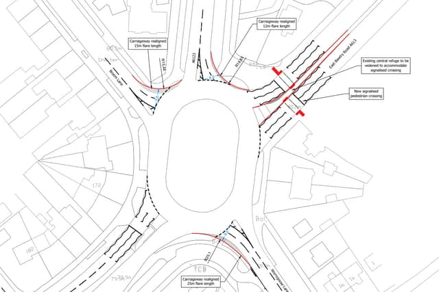
The suggested agreement with the developers includes highways improvements at the roundabout (below). These comprise widening Worrygoose Lane, a 500-metre bus lane on the A631 East Bawtry Road to the west, widening the Broom Lane and Herringthorpe Valley Road approaches and adding a pedestrian crossing on West Bawtry Road to the east.
Other suggested requirements of the agreement are £500 per dwelling for sustainable transport, £300,000 for bus services and “education contributions in accordance with the council’s adopted policy.”
Advertisement
Hide AdAdvertisement
Hide AdThe huge opposition to the plan has seen 320 letters of representation sent to the council, including three from Whiston Residents Action Group (Wrag), one letter from the village’s parish council and another from Alexander Stafford MP.
A Wrag spokesman said: “Local residents can confirm that there are already major traffic congestion problems at peak times in this area, leading to delays.
“Cars from 450 additional dwellings will add greatly to this problem, and the proposed building of additional dwellings at Dinnington will further increase the traffic travelling down Royds Moor and along Worrygoose Lane.”
The parish council said drainage and flood risk issues had not been adequately considered, with “real risk” of worsening the area downstream, which was affected by the 2007 and 2019 downpours.
Advertisement
Hide AdAdvertisement
Hide AdRother Valley MP Mr Stafford accused RMBC of failing to address concerns about transport, with congestion “considerable and worsening.”
The land was removed from the greenbelt and suggested for housing by Rotherham Council's Local Plan in 2018.
A spokesman for the authority said the plans were acceptable in terms of highway safety, open space, drainage, ecology and landscaping.
“The scheme is considered to be sustainable and has notable benefits in terms of market and affordable housing provision and associated social and economic benefits arising from such provision,” he added.
Advertisement
Hide AdAdvertisement
Hide Ad“Development in this location will support the ongoing delivery of services and facilities within the local area and provide much-needed market housing to meet Local Plan targets for housing development within the plan period to 2028.”